- Home
- Technical Cooperation Projects
- Index of Countries
- Latin America
- Panama
- Project for Participatory Community Development and Integrated Management of the Alhajuela Lake Subwatershed
- Project News
- Training at the National Geographic Institute "Tommy Guardia" of the Ministry of Public Works
Project News
2008-10-24
Training at the National Geographic Institute "Tommy Guardia" of the Ministry of Public Works
From September 8 to 10, the Project's extension workers were trained in topographic survey at the National Geographic Institute of the Ministry of Public Works. The purpose of this training was to strengthen their ability in making the "farmland use plans", which we presented in an earlier Project News. By comparing the high-precision land survey done by professionals with the simple survey that we do, we could compare the advantages and disadvantages of the two and find the best method for our needs. In this training we received the cooperation of a JICA Senior Volunteer currently working at the National Geographic Institute.
Besides the Project's extension workers, several young staff from ANAM's (National Environmental Authority) Directorate for the Integrated Management of Watersheds also participated in the training. On the first day, lectures were given on the history of land survey and the GPS (Global Positioning System) (photo 1). The participants were impressed to hear the experiences told by the National Geographic Institute's personnel about surveying the national border in a dangerous tropical jungle or the trials suffered for making errors of only a few millimeters.
On the second and third days, participants went to the Institute's parking lot where they practiced topographic survey using a high-precision GPS and a total station (photos 2 & 3). They found that there is a great difference between listening to a lecture and actually operating an instrument. All the participants took turns in practicing making measurements of the parking lot and finally measured, with repeated assistance, the altitude and coordinates of the parking lot border.
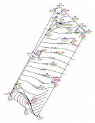
The topographic map they made on the last day had some minor details that did not reflect reality, but to the participants it was a great inspiration to see the concrete result of everyone's efforts (photo 4). From now on, we plan to introduce this technology at the Project sites to fulfill the purpose of watershed management, but in consultation with the local inhabitants to find the most practical way to apply it on their farms.
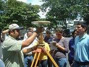
(Photo 1, left) Staff from the National Geographic Institute "Tommy Guardia" giving a lecture. (September 8, 2008)
(Photo 2, right) Practice in measuring a position using a high-precision GPS. (September 9, 2008)
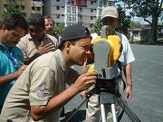
(Photo 3, left) Mr. Alexander, Project personnel, makes a measurement. (September 9, 2008)
(Photo 4, right) The fruit of the surveying efforts brings much satisfaction. (September 10, 2008)
(Mr. Taku MORI, Farmland Use Plan / Environmental Education)