Project News
2008-11-21
Getting to Know the Group Farms
Currently, our Project has farmer groups in 14 communities and each group has established a group farm as a center for learning environment-friendly farming techniques. Today I would like to introduce these group farms to our readers. All of them have different situations, such as the following:
- Location and topography (located inside or outside the National Park, in the hills or on the lakeshore, flat or sloped terrain)
- Surface area (from 0.2 ha., the smallest, to 3.5 ha., the largest)
- Group formation, some were organized by our Project for the first time, while others were organized previously and had common land, which was then set up as the group farmland for their activities.
Besides these differences, there are also many other different conditions faced by the groups, such as: some have a water source while others don't; some have good access, others don't; and the level of experience and skill in applying the farming techniques also differs among the group members. In the Project we are applying and promoting the different farming techniques in accordance with the characteristics of each farmer group. We will introduce these techniques one by one in the coming Project News.
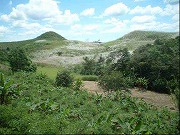
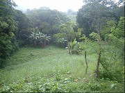
(Photo 1: left) This is the Santa Librada group farm. It is located inside Chagres National Park and has sloped land surrounded by forest and clear running streams. (October 1, 2008)
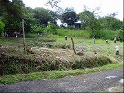
(Photo 2: right) The Chilibrillo group farm. It is located outside the National Park and close to a main road. Its land is flat to moderately sloped, and is surrounded by canal grass. (October 17, 2008)
(Photo 3: left) This is the Peñas Blancas group farm. It is inside the National Park with level land close to the lakeshore. (June 12, 2008)
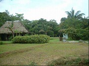
(Photo 4: right) The Nuevo Vigia group farm. It is outside the National Park in a semi-urban area with a large population. The land is small, not quite 0.2 ha. (October 17, 2008)
(Photo 5: left) The Victoriano Lorenzo group farm is located inside the National Park. It is on sloped land and is small and surrounded by forest. (June 20, 2008)
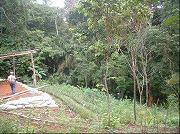
(Photo 6: right) The Salamanca group farm is outside the National Park. It has a steep slope, going down from the foreground to the background in the photo, and the bottomland is flat. (July 7, 2008)
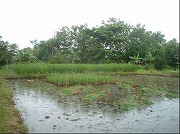
(Photo 7: left) The Tranquilla group farm. It is inside the National Park and located on a small peninsula that extends into the lake. The photo shows their rice-paddy production. (July 9, 2008)
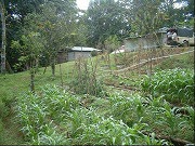
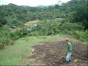
(Photo 8: right) The Madroñal group farm is outside the National Park. It is on the top of a ridge and also circles around the end of the ridge. In the background you can see the houses of the community. (July 10, 2008)
(Mr. Taku MORI, Farmland Use Plan / Environmental Education)