Project News
2011-01-06
Developing detailed land use maps
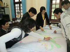 Participants are discussing on land use categories should be applied on the in-depth land use maps by comparing with the existing land use map
On 6 January 2011, a meeting on discussing on the technical matters of in-depth land use survey for developing detailed land maps was held participated by responsible officers of Province, and Dien Bien and Dine Bien Dong Districts. The existing current land use and land use plan maps of each commune are neither detailed nor exact enough for conducting Pilot Activities in each Pilot Site. Thus, the project is conducting in-depth survey and developing the detailed land use maps, hiring Northwest Sub-Forestry Inventory and Planning Institute (NW-FIPI).
In this meeting participates discussed on the technical and financial proposals, which submitted by NW-FIPI.
Through the discussions, land use categories applied on the maps, required types of the maps (i.e. whether current land use maps are separated from land tenure maps?), and the method of verification and approval of the products are confirmed.
- About JICA
- News & Features
- Countries & Regions
- Our Work
- Thematic Issues
- Types of Assistance
- Partnerships with Other Development Partners
- Climate Change / Environmental and Social Considerations
- Evaluations
- Compliance and Anti-corruption
- Science and Technology Cooperation on Global Issues
- Research
- JICA Development Studies Program / JICA Chair
- Support for the Acceptance of Foreign HRs / Multicultural and Inclusive Community
- Publications
- Investor Relations