- Home
- Technical Cooperation Projects
- Index of Countries
- Asia
- Viet Nam
- Project for Building Disaster Resilient Societies in Central Region
- Project News
- Topographic survey equipment was provided and training was started
Project News
2011-04-01
Topographic survey equipment was provided and training was started
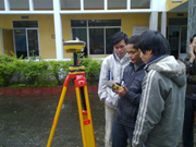
Dual frequency GPS equipment was provided to T.T.Hue on March 30. The training of this equipment was held from March 30 to April 1st.
All counterparts attended to this training. Attendants were in mild embarrassment at first because this is quite new equipment. However all attendants skilled soon because they have many experience for the topographic survey.
This equipment will be used for the flood mark survey which has been carried out every year in this project. Very accurate elevation and location (longitudinal and latitude) can be surveyed by this equipment. By using surveyed data, Vietnamese counterparts can prepare map of inundation, verification data of the flood simulation etc.
- About JICA
- News & Features
- Countries & Regions
- Our Work
- Thematic Issues
- Types of Assistance
- Partnerships with Other Development Partners
- Climate Change / Environmental and Social Considerations
- Evaluations
- Compliance and Anti-corruption
- Science and Technology Cooperation on Global Issues
- Research
- JICA Development Studies Program / JICA Chair
- Support for the Acceptance of Foreign HRs / Multicultural and Inclusive Community
- Publications
- Investor Relations
Copyright © Japan International Cooperation Agency