- Home
- Technical Cooperation Projects
- Index of Countries
- Asia
- Indonesia
- Integrated Disaster Mitigation Management Project for "Banjir Bandang"
- Project News
- Supported making of the Banjir Bandang Hazard Map.
Project News
2012-03-06
Supported making of the Banjir Bandang Hazard Map.
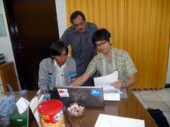 Mr. Yoshida Expert discussed with staffs of BWS Sulawesi III.
Mr. Yoshida Expert went to the village, where the Banjir Bandang disaster was occurred in December, 2011, for the investigation in January, so that he suggested that it had high potential area for deep-seated landslide which was cause of the Banjir Bandang by the characteristics of geological and topographical factors. Then JICA supported making of the Banjir Bandang Hazard Map around the village. Moreover Mr. Yoshida Expert visited the Sulawesi 3rd River Office in Ministry of Public Works (BWS Sulawesi III) after finishing the analysis by GIS, and explained the Banjir Bandang Hazard Map to staffs of the BWS Sulawesi III. After his explanation they discussed the establishment of early warning system for Banjir Bandang.
Mr. Yoshida Experts also heard investigation results by BWS Sulawesi III, so that advised about installing locations of rainfall gauges, level for warning. The staffs of the BWS Sulawesi III presented their expectation that it would be installed as soon as possible.
Finally Mr. Yoshida Expert handed over the laptop with GIS software to use for making Banjir Bandang Hazard Map in another area.
- About JICA
- News & Features
- Countries & Regions
- Our Work
- Thematic Issues
- Types of Assistance
- Partnerships with Other Development Partners
- Climate Change / Environmental and Social Considerations
- Evaluations
- Compliance and Anti-corruption
- Science and Technology Cooperation on Global Issues
- Research
- JICA Development Studies Program / JICA Chair
- Support for the Acceptance of Foreign HRs / Multicultural and Inclusive Community
- Publications
- Investor Relations