Outline of the Project
Title
The project for Nacala Corridor Economic Development Strategies in the Republic of Mozambique
Country
Mozambique
Date of R/D Signed
November 18, 2011
Term of Cooperation
March 2, 2012 to December 20, 2013
Counterpart
Ministry of Planning and Development,
GAZEDA (Gabinete Das Zonas Económicas de Desenvolvimento Acelerado).
Background
(1) The Nacala Corridor in Mozambique and the Wider Context of Southern Africa
The Nacala Corridor is located in the Northern Region of Mozambique, and it extends from the Nacala Port to inland districts of Mozambique and further to neighboring countries, such as Malawi and Zambia. It was a historically international transport corridor consisting of Nacala Port and Northern Railway and Malawian Railway System. The Nacala Corridor was the most important export route for Malawi in those days. However, the prolonged civil war in Mozambique had disturbed international transport through the Nacala Corridor.
Since the end of the civil war in 1992, devastated infrastructures of Mozambique have been rehabilitated by international aid from various donors. However, development has not reached the Nacala Corridor and its surrounding areas in the Northern Region. Both the Nacala Corridor and the Northern Region are very far from the national economic centre, the nation’s capital Maputo, and their economy is not well integrated with the Southern Region’s economy.
Although these railway operations of the Nacala Corridor have been privatized since 2005, the private operators have not secured enough funds to rehabilitate railway infrastructures and rolling stocks because there were not so much demand for cargo transport. As a result, malfunctioning of cargo railway transport has hindered anyone from envisioning future economic development for the areas related to the Nacala Corridor. Although in the late 1990s and the early 2000s, the Nacala Corridor Initiatives were active and appealing, such initiatives have almost disappeared since the middle of 2000s.
In recent years, the Nacala Corridor restarted attracting attention from people and businesses. Actually long-distance ocean liners started to visit Nacala Port for connecting with Asia. Nacala Port’s hinterlands also attracted investments in industrial development. Japan International Cooperation Agency (JICA) and Africal Development Bank (AfDB) and other banks decided to co-finance road upgrading projects including Nampula-Cuamba and Lichinga-Montepuez. They have considered financing further a road connecting Cuamba with the Malawi side.
In addition to the trunk road development projects and increased investments in Nacala Area, large-scale coal exploitation in Tete Province needs to develop export routes in addition to the Sena Railway and Beira Port. One of the additional export routes is the Nacala Corridor’s railways and Nacala Port.
(2) The Region of the Nacala Corridor in Mozambique
The areas which might be economically, socially or environmentally under the influence of the Nacala Corridor are much larger than immediately surrounding areas of the transport infrastructures, such as railways and roads. When its transport infrastructures (railways and trunk roads) are upgraded, the areas to be influenced by the Nacala Corridor would cover large part of the five provinces: namely Nampula Province, Niassa Province, Cabo Delgado Province, Zambezia Province and Tete Province.
The five provinces (in Mozambique) related to the Nacala Corridor have over 499,000 km2 and approximately 14 million population (2011).
Essential characteristics for these provinces in regional development of the Nacala Corridor include the following:
- Nampula, Niassa and Zambezia Provinces have high development potential for agriculture and tree plantations because of extensive availability of relatively good soils and climate.
- Nacala Port is a deep sea port that has possibilities of becoming a gateway of the Nacala Corridor to the world.
- Cabo Delgado Province will be under the influence of the Nacala Corridor. It is because regional development in the Nacala Corridor might need to use more water of the Ruvuma River and the Lurio River, both of which are running through the borders of Cabo Delgado Province.
On the other hand, there are some areas which might also influence the development of the region of the Nacala Corridor. Tete Province is one of them. In Tete Province, large-scale coal exploitation is underway. Its coal mining operations are considered to have the potential to be expanded several times larger than the current ones.
Hence, there are great expectations regarding the future economic development including agriculture, forestry, industry and tourism sectors in the Nacala Corridor Region.
(3) Need for Development Strategies for Sustainable Development of the Nacala Corridor
Various government projects are underway with assistance by donors, and many investments of private sectors are also coming to the region of the Nacala Corridor. However, there are concerns about unplanned or uncoordinated developments which have been mostly promoted by private sectors in the region. The issues of concern include excessive exploitation of water resources, lands and other environmental resources, as well as urban environmental deterioration and industry-related pollution.
Under such circumstances, the Government of Mozambique considers the necessity to update existing development plans concerning the Nacala Corridor and to formulate integrated development strategies for the Nacala Corridor as a whole.
In this connection, the Government of Mozambique requested the Japanese Government to provide assistance for the Project for Nacala Corridor Economic Development Strategies in the Republic of Mozambique (hereinafter referred to as “the Project”), and both governments agreed to implement the Project as agreed in the Record of Discussion.
The Project aims to contribute to promote sustainable development and to attract investments in the Nacala Corridor Region through preparation of development strategies based on analysis of constraints and potentials of the region.
Overall Goals
- To enhance social capacity and economic growth in the Nacala Corridor
- To effectively guide appropriate development in the Nacala Corridor
- To promote private investment in the Nacala Corridor
- To appropriately manage resources of the Nacala Corridor
Project Purpose
To formulate development strategies to guide appropriate development and investment in the Nacala Corridor.
Outputs
- Integrated development strategies for the Nacala Corridor
- Database of various sectors in the Nacala Corridor, including GIS dat
- Topographic maps for selected areas in the Nacala Corridor (Cities of Nampula and Nacala)
Activities
- Review of existing development plans, development projects, studies, and public and private investments in the Nacala Corridor
- Collection of available data and information concerning the Nacala Corridor including Tete Province
- Collection of available data and information and review of existing development plans and projects concerning neighboring countries
- Collection and preparation of GIS data for establishing GIS database
- Preparation of topographic maps for selected areas
- Preparation of database of socio-economic and sector situation on the Nacala Corridor
- Analysis to identify constraints to development, factors of promoting development, and potential for development
- Establishment of a planning framework
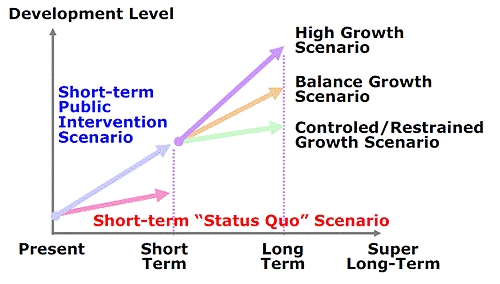
- Analysis by preparing alternative development scenarios
- Strategic environmental assessment of development strategies for the Nacala Corridor
- Formulation of integrated development strategies for Nacala Corridor
- Recommendation of measures to complement on-going and planned development strategies
- Formulation of projects in selected sectors in accordance with the integrated development strategies
- Prioritization of existing and proposed development projects
- Capacity development of Planning and monitoring for development of the Nacala Corridor
- Holding the international seminar on the progress and achievements of the project
Inputs
- Inputs by JICA
Dispatch of Mission (37members as follows)
Team Leader / Regional Development Strategy, Deputy Team Leader 1 / Integrated Development Planning/ Regional Information Database, Deputy Team Leader 2 / Integrated Infrastructure Planning / Infrastructure Information Database, Group Leader for Integrated Development Planning / Regional Development Planning / Land Use Planning/ Regional Economy 2, Regional Economy 1, Logistics, Logistics Survey / Analysis, Spatial Analysis / GIS Analysis, Mining Sector Development, Industrial Sector Development, Agricultural / Forestry Sector Development, Tourism Sector Development, Investment Promotion / Private Sector Support, Development Administration System / Organization / Legal System, Human Resources Development,
Water Resources Development / Water Balance Analysis, Environmental Regulations / Strategic Environmental Assessment, Social System, Social Services, Electric Power Development and Supply, Telecommunications, Cross-Border Facilities (Road & Railway), Road Planning(Urban and Regional Roads),Urban Planning, Urban Land use Planning / Industrial Estate Development, Urban Water Supply, Rural Water Supply, Urban Sewerage and Industrial Wastewater Treatment, Port Planning, Railway Planning, Topographic Mapping 1 (Leader), Topographic Mapping 2 (Control Point Survey Supervision), Topographic Mapping 3 (Field Survey Supervision), GIS Data Development, Project Assistant 1 / Regional Planning, Project Assistant 2 / Social System & Service, Interpreter 1, Interpreter 2
Inputs by Mozambique
- Services of GAZADA’s counterpart personnel and administrative personnel.
- Available data and information related to the project
- Running expenses necessary for the implementation of the project.
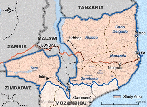 Study Area
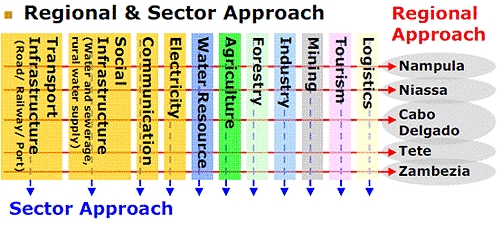 Study Approach
 Study Approach
- About JICA
- News & Features
- Countries & Regions
- Our Work
- Thematic Issues
- Types of Assistance
- Partnerships with Other Development Partners
- Climate Change / Environmental and Social Considerations
- Evaluations
- Compliance and Anti-corruption
- Science and Technology Cooperation on Global Issues
- Research
- JICA Development Studies Program / JICA Chair
- Support for the Acceptance of Foreign HRs / Multicultural and Inclusive Community
- Publications
- Investor Relations