Protecting the earth from natural disasters are ... satellites? On the front lines of space development and disaster risk reduction as seen in Guatemala, Central America!
2022.05.20


GetNavi editorial department
Space development and disaster risk reduction. Did you know that, while these two fields may seem completely unrelated at first glance, they are actually intrinsically linked?
With Yusaku Maezawa's space trip to the International Space Station still fresh in the memory, work on space development projects by a whole host of private companies is now turning heads. Elon Musk's SpaceX, Jeff Bezos' Blue Origin and other space companies are now household names.
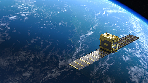
Space is not just a travel destination, it now also a place where we can solve a broad range of the earth's problems. This time we will look at the efforts of Synspective, a Japanese start-up developing the SAR satellite [1] , which can be used to observe changes in the earth's surface, even at night and during inclement weather.
How are satellites used to address the recent spate in natural disasters felt across all parts of the globe, partly as a result of climate change?
In this article, Seiko Shirasaka from Synspective, Haruo Hayashi, President of the National Research Institute for Earth Science and Disaster Resilience (NIED), a research institute researching ways to achieve a disaster-resilient society, and Satoshi Yoshida, Director General of Latin America and the Caribbean Department at JICA, which provides international aid to emerging countries sat down for a multi-faceted three-way discussion on the use of satellites in disaster risk management.
[Let's hear from the experts!]
Seiko Shirasaka
Founder of Synspective Professor, Graduate School of System Design and Management, Keio University. After completing a master's degree in Aeronautics and Astronautics at the University of Tokyo, Seiko has continued down the path of space development. From 2015 to 2019, Seiko was involved in the development of a made-for-order compact synthetic-aperture radar (SAR) satellite system as program manager of the Cabinet Office's Impulsing Paradigm Change through Disruptive Technologies Program "ImPACT".
Haruo Hayashi
President, National Research Institute for Earth Science and Disaster Resilience (NIED). Professor Emeritus, Disaster Prevention Research Institute, Kyoto University. Earned PhD in 1983 from the University of California, Los Angeles. Majored in social psychology and crisis management. Received The Prime Minister's Award in 2013 for distinguished service in disaster risk reduction. Member of the Science Council of Japan, Member of the Basic Policy Subcommittee of the Space Policy Committee, Member of the Advisory Board for the Promotion of Science and Technology Diplomacy, Ministry of Foreign Affairs of Japan. Author of many books on disaster risk reduction.
Satoshi Yoshida
Director General of the Latin America and the Caribbean Department of the Japan International Cooperation Agency (JICA). Satoshi left his job as a bank employee to become a Japan Overseas Cooperation Volunteer (JOCV). After a two-year in the Dominican Republic in Central America, Satoshi joined JICA in 1994 upon his return to Japan. His first overseas posting was in Brazil, where he was involved in various international cooperation projects, including a project to transform the Cerrado region, a barren tropical savanna region, into the largest farmland in the southern hemisphere.
JICA - Satoshi Yoshida (abbreviated as Yoshida hereafter): While many people might wonder how space can be tied back to disaster risk reduction, in reality "space data" from satellites is actively used around the world, and ways in which satellites can be used in the field of disaster risk reduction is garnering particular attention.
One such example of this was a project JICA worked on with Shirasaka's team at Synspective in Guatemala involving the use of satellites to analyze changes in the earth's surface to benefit disaster risk reduction responses.
Synspective - Seiko Shirasaka (abbreviated as Shirasaka hereafter): Synspective is a company that seeks to provide solutions to problems using SAR satellite technology. While I will delve into more detail later, while satellites seemingly bear little relation to disaster risk reduction at first glance, this is a topic that I have long sought to address, and is also the reason behind Synspective's founding.
Yoshida: In the same way, while JICA's international cooperation projects used to conjure up an image of dispatch teams digging a well in some developing country, nowadays there has been a significant increase in the number of disaster risk reduction cooperation projects we have been involved with. Natural disasters such as flooding, earthquake, landslides, and drought have caused major damage in Guatemala, and other parts of Central America and the Caribbean. I once visited the Dominican Republic as a JOCV, but there has been a night and day difference in the scope and frequency of disasters now plaguing the region.
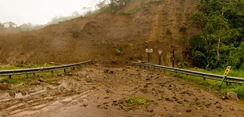
Scenes of a landslide that occurred in Costa Rica, Central America.
NIED - Haruo Hayashi (abbreviated as Hayashi hereafter): While the definition of disaster risk reduction changes over time, we at the National Research Institute for Earth Science and Disaster Resilience (hereafter, NIED) have focused on the development of SCIENCE FOR RESILIENCE. This word resilience [2] pops up a lot recently.
Yoshida: Lately, the Build Back Better concept following a disaster has been attracting a lot of attention.
Hayashi: Exactly. "Disaster risk reduction" has traditionally focused on avoiding all damage, but in reality this is difficult to achieve. There has been a dramatic spike in the number of disasters occurring around the globe, which predominantly due to wind and flood damage. Despite our best efforts to research on preventing disaster, complex factors including climate change and population increases have led to increased damage from disasters.
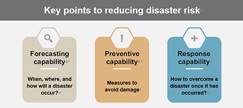
Under such circumstances, a common theme for disaster risk reduction is to "reduce the risk of disasters". At NIED, we conduct science and technology research that aims to address three core goals - "limiting damage from natural disasters", "preventing the spread of damage", and "realizing the quick recovery and restoration of affected areas".
Reducing the risk of natural disasters requires the forecasting capabilities to predict when, where, and how a disaster will occur, the preventive capabilities to prevent damage from occurring, and the response capabilities to overcome disasters once that have occurred.
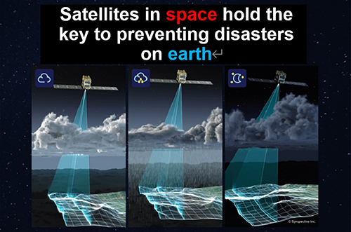
Shirasaka: Before delving too deeply into the details of the project in Guatemala, I would like to briefly go over the satellites we develop here at Synspective. SAR is an abbreviation of Synthetic Aperture Radar. While I will not go into detail about how it works, the main feature of a SAR satellite is its ability to observe changes on the earth's surface, even under the cover of night or in poor weather.
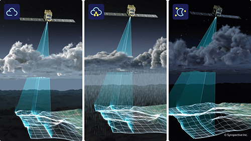
A compact SAR satellite capable of image capturing regardless of time of day or weather. One distinctive feature is its ability to observe the earth's surface using images that could not be captured with a camera onboard a regular earth observation satellite.
While there are a variety of different observation satellites in operation, the vast majority are optical satellites - that is, satellites with an onboard camera. However, cameras have a weakness in that they only allow for observations to be performed during the daytime, and cannot see through cloud cover. To overcome this weakness, the SAR satellite uses radar instead of a camera. Radio waves (micro waves) are sent to the earth from an antenna attached to the satellite, and the reflected wave that bounces back up to the satellite is measured. Radio waves can pass through clouds, and do not require sunlight.
Hayashi: The technology to investigate without contact using satellites and drones is referred to as remote sensing, and this has fast become a key concept in the world of disaster risk reduction. In addition, the ability of SAR satellites to observe the earth's surface at night, and during cloudy and other inclement weather conditions has proven extremely effective for disaster risk reduction.
Shirasaka: That's right. I have long been part of what is known as the "space community". Up to now, space development has progressed over long periods of time using taxpayer money. We have developed technologies on the basis that they would be used as part of disaster response efforts. In reality, the Great East Japan Earthquake in 2011 showed us that the results of Japan's space development efforts proved largely unusable.
The money that had been used in the name of aiding a disaster response could not be used effectively in the face of an actual widespread disaster. This brought about a strong sense of resolve for those of us in Japan's space development program. The launch of ImPACT [3] in 2014 led to the development of a synthetic-aperture radar - that technology development upon which SAR is based - which I led as program manager with a fervent desire to develop something that could actually be used in the face of a natural disaster.
Yoshida: The SAR satellite was chosen as part of the ImPACT research and development program as a result of this earthquake, wasn't it? When you say the space program's technologies could not be used effectively when the earthquake occurred, what was the reason for this?
Shirasaka: In the face of widespread damage, such as that caused by the Great East Japan Earthquake, there are limits to the area in which airplanes and drones can observe. You really need a satellite to cover this area. With an optical satellite, the satellite needs to be stationed over Japan to capture images of Japan. Those responding to the disaster could not view these satellite images when they were needed the most.
In technical terms, "resolution" is used to describe the degree of detail to which a satellite can capture images of a point on the earth's surface. "Spatial resolution" is used to describe the level of detail the physical observation area can be observed, while "temporal resolution" refers to the frequency, or cycle said area can be observed.
It all depends on how quickly we provide information on the earth's surface captured by the satellite to those who need it most. Research on the SAR satellite program as part of ImPACT focused on this "readiness" factor.
Hayashi: I felt a great deal of affinity with Mr. Shirasaka's strong desire to produce something that can actually be used in the face of a disaster. What those working in the field of disaster risk reduction need most is the ability to maintain an understanding of the scale of the disaster, and the disaster situation. Even though it is difficult to have an accurate and complete understanding of the disaster situation, we also need to respond quickly in the event of a disaster. This was the idea behind using a satellite that could quickly provide an overall picture of the disaster situation over a broad area, wasn't it?
Shirasaka: That's correct. Afterwards, it was decided that incorporating the results of ImPACT research into society would be better handled by a private entity as it would take too long for government to act, which led to the founding of Synspective. The company name is an abbreviation of "Synthetic Data for Perspective on Sustainable Development", and is taken to mean using synthetic data for a sustainable future.
Incidentally, the word "synthetic" in SAR refers to the fact that the radar increases in spatial resolution the larger surface of the antenna aperture becomes. However, ideally you want to make satellites as small and lightweight as possible due to the costs attached to launching a rocket. A SAR satellite transmits radio waves while moving and "synthesizes" the measurement results obtained to create a large, virtual aperture surface. This gives a SAR satellite a high spatial resolution while maintaining a small antenna on a compact satellite.
Yoshida: The countries of Central America and the Caribbean face widespread damage from cyclones and typhoons every year. The region also experiences earthquakes and landslides. Disasters have long since plagued the region. The former capital of Guatemala, Antigua Guatemala, was once destroyed in a major earthquake, and what was left of the city is now a World Heritage site.
Further, the country is situated in a complex mountainous region, with each region virtually cut off from one another. This causes communication challenges in the event of a disaster, and it is difficult to determine who needs what. With this in mind, we partnered with Synspective to conduct demonstration testing using SAR satellites to gather various information. Mr. Shirasaka, would you mind going over the key benefits of using a SAR satellite for disaster risk reduction?
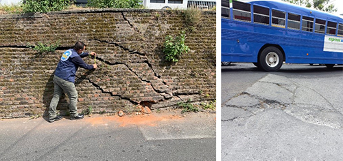
Ground deformation in Guatemala City has caused cracks to appear in walls and roads.
Shirasaka: Monitoring the earth's surface using satellites, including optical satellites, offer four key benefits.
[Four benefits of satellite monitoring]
In particular, fixed point observation, that is, continual monitoring, is a crucial advantage. This allows multiple satellites to be linked together to form a single system, or constellation (satellite group) to increase monitoring resolution.
This project involved the use of Synspective's LDM (Land Displacement Monitoring) system to observe land displacement such as land subsidence, and landslides. To achieve this, a technology called Interferometric SAR was used.
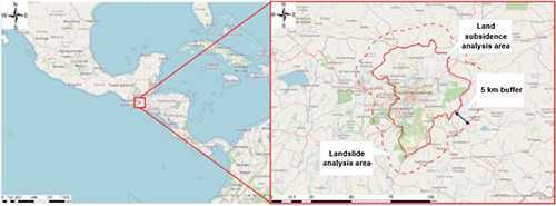
Subject area (Background map: OpenStreetMap (and) contributors, CC-BY-SA)
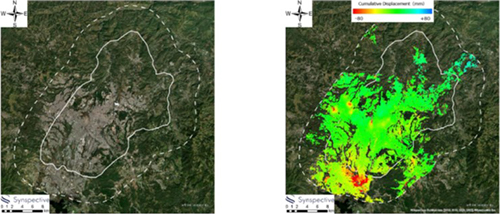
Area of Guatemala City and surrounding suburbs subject to demonstration testing by Synspective and JICA (above). Observations made it possible to confirm a general tendency for serious land subsidence in localized areas, and points at risk of collapsing and landslides (below). ©Synspective Inc.
An interferometric SAR bounces two radio waves off the earth's surface at different times. If land displacement has occurred, the wavelength will be slightly off. This ability to see the displacement in the first and second wavelength allows us to measure displacement of the earth's surface to the millimeter. This project looked for parts of Guatemala City where subsidence was occurring, and whether there were areas in the mountains where a landslide could occur.
Yoshida: While interferometric SAR itself is not a new technology, Synspective's unique interferometric SAR system enables vertical movement and horizontal movement to be tracked separately.
Shirasaka: To put it in simple terms, when opening a hole in the ground, the ground sinks vertically. However, when seen from the side, the ground is drawn inwards toward the center. In other words, viewing vertical and horizontal ground movement allows us to make predictions about where subsidence is likely to occur. Conversely, this technology can also be used to predict mountain forming by observing the vertical movement of the mountain as it rises, together with the horizontal movement of the ground from the surrounding area coming together.
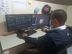
Next, LDM is used to provide the data obtained from the SAR satellite on a display that can be viewed by people in charge of disaster response efforts. This data is provided in an SaaS [4] format, and can be accessed by any PC or Internet-connected device.
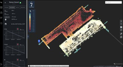
Demonstration and introduction of the Land Displacement Monitoring (LDM) solution service used to analyze land displacement over a wide area based on satellite data, and provide the analysis results. Continued use is expected to streamline measurement operations, and allow for the early discovery of areas with the potential risk of land displacement.
Yoshida: The data collected over a wide area using SAR satellite imagery on this project helped identify three critical hazard points that had not been known to Guatemalan authorities. The use of LDM has made it possible to update hazard maps based on quantitative information, including data on the amount of displacement occurring on the earth's surface. This is expected to greatly alleviate the workload that used to be required to perform measurements.
Shirasaka: In addition to the predictive and preventive capabilities implemented for this project, we hope to have SAR satellites contribute in a responsive capacity following a disaster in the future. Mr. Hayashi, you have provided advice as a disaster risk reduction specialist from the days when ImPACT still did not have a working satellite. What is your opinion of SAR satellites at the current time, and what challenges still lie ahead?
Hayashi: Cases of storm and flood damage are increasing across the globe. Our ability to view the earth's surface from a satellite equipped with an optical camera is limited when cloud cover is present. To be able to peer through the clouds and see what is going on in human society at ground level requires the use of a SAR satellite. Synspective's efforts in implementing SAR satellites, and its plans for constellations of small satellites, are really quite an achievement.
Above all else, Synspective's information products are also really easy to understand. LDM presents data in the form of heat maps and other visual formats to show how the earth has moved, and the differences in topography, in a manner that can be understood by someone who is not a specialist in satellites. I think this is truly terrific.
Having said that, there still are not enough satellites in the sky. A single SAR satellite by itself has a low temporal resolution, and cannot be used as part of a disaster response. Forming constellations of small satellites to improve the temporal resolution will lead to these satellites being used effectively in the field of disaster response.
Yoshida: Actually, at JICA we have also taken an active interest in satellites, and since 2008 we have been working on a project to monitor illegal logging in the Amazon region of Brazil using satellites.
Even though the Amazon is technically a river, it resembles an ocean in many ways, and it is constantly covered by steam and cloud. To get around this, we employed the use of a SAR satellite developed by the Japan Aerospace Exploration Agency (JAXA) called "ALOS". We had some success in clamping down on illegal logging by establishing a framework for sharing this data with an organization under the Ministry of the Environment in Brazil, and providing it to the federal police.
With this project making real inroads, looking ahead we hope to continue using satellite data in other international cooperation projects.
Shirasaka: At Synspective, we are not experts in disaster risk reduction. For example, if an earthquake were to occur, we would not be able to decide what images to capture. In this respect, a clear division of roles by specialty is needed. To this end, we are currently collaborating with NIED.
Hayashi: The data we receive from the so-called satellite experts is always missing key information (laughs). Capturing images of a disaster is meaningless if the images are not taken of the right place at the right time. This "capture timing" and "capture location" are known as triggering information. I see NIED's role as providing this information.
As the constellation (satellite group) expands in the future, we could use SAR satellites as part of rapid emergency services in the event of a disaster, which would prove extremely beneficial.
Shirasaka: If we can establish a constellation of 30 satellites, we would be able to capture images anywhere on earth within two hours, and anywhere in Japan within an hour, on average. Our goal is to be able to download and process the data, and pass it on to those in the field within two hours.
Yoshida: A private company needs to have a sustainable business. Could you tell us of your business strategy for the SAR satellite business?
Shirasaka: Right now, more than anything else, we need feedback. The more our products are used in the field, the better they will get, until they are eventually easy to use by people in other areas. In addition to our satellite development team, we also have a services team.
Disaster responses are typically thought of as something handled at a national level, making it difficult for a private company to engage in direct sales activities. This is where public institutions such as NIED and JICA come in, and JICA is a reassuring partner to have due to its involvement in disaster risk reduction cooperation projects around the globe.
Demonstration testing in Guatemala by Synspective and JICA.
Hayashi: In terms of business sustainability, we see in the U.S. that products from such startup ventures are ordered and purchased in bulk by government bodies. This gives these companies the backing to keep producing more products. Establishing this cycle has been key to the U.S. developing the private sector while advancing its satellite technologies.
Hypothetically speaking, JICA, and the Ministry of Foreign Affairs in Japan would greatly benefit from having your own satellite information updated in real-time, and on a regular basis. Wouldn't establishing such an environment provide a great deal of stability to the small satellite constellation business in Japan and foster significant growth in this area?
Yoshida: The countries that JICA partners with on international cooperation project do not always have a large budget to work with, and many countries do not have their own satellites. I would like to ask you Mr. Hayashi, what could be done in these countries to bolster their disaster forecasting, prevention, and response capabilities?
Hayashi: In that sense, Japan is really no different at a municipal level. Despite this, one of the reasons Japan is said to be a world leader in disaster risk reduction is the systems it has in place for information gathering at a broader national and prefectural level and sharing to all, rather than by individual municipalities.
In that sense, we need to view things along the lines of not simply utilizing Japanese technology and knowledge for Japan's benefit, but rather to consider Japan's future position within a broader global framework.
Yoshida: You're absolutely right. At JICA, while we will continue to address individual issues on an independent basis, we are also shifting toward addressing these issues within a broader context. Simply seeking to address issues faced within a specific country limits your ability to apply solutions elsewhere, and you end up sort of playing a maniacal game of whack-a-mole.
Shirasaka: One more thing about business. In the future, as compact, lightweight satellites become increasingly available and cost barriers to acquiring satellite data are lowered, the user base will expand and come up with new ways to use satellite data.
In the early days of computing when the only computers were massive mainframe supercomputers, nobody would have thought about doing one's accounts on a supercomputer. Now that computers and smartphones are readily available at a reasonable cost, people have come to use these devices to do the accounts. I think you are going to see the same phenomenon occur as satellite data becomes cheaper. That is why I want to see more and more people around the world launching satellites.
From a business perspective it might seem like a better idea to have exclusive control of our own satellite data, but that is not how things are being done now. By making the data available to everyone we hope to expand the market for satellite data, and capture a share of that market. Not only will this end up boosting profitability, I think this will make our business easier to run, and lead to the further development of the space industry.
Yoshida: I feel in complete agreement with the both of you in your desires to expand by refusing to monopolize.
Just like, for example, if a tsunami or earthquake were to occur in Chile, a tsunami or earthquake would be felt in Japan, the world is connected. At JICA, we are helping train over 2,000 personnel specializing in disaster risk reduction, primarily in Chile, and are planning to increase this number further. This is done not only to benefit Chile, but also to benefit Japan, and the rest of the world. Rather than tackling issues individually, we work to solve problems within a broader context as part of a global agenda, or alternatively, in a way that is of interest to as many people as possible. I think ultimately this ties back to JICA's vision for "Leading the world with trust".
I think this concept fits especially neatly into the disaster risk reduction and space initiatives introduced today, and I hope we can continue to cooperate in this manner in the future. Thank you for your time today!
Notes
[1] SAR : Synthetic Aperture Radar. In contrast to a conventional optical-type earth observation satellite, a SAR satellite is capable of capturing detailed images of the ground even at night, or when cloud cover is present. In particular, Interferometric SAR (or InSAR for short) is the technique used to make multiple observations of the earth’s surface using SAR, and then capture changes based on phase differences between each.
[2] Resilience : A word that incorporates meanings of an "adaptive and transformative capacity of recovery", in addition to "preventive capability". It is interpreted as the strength of individuals, organizations as well as nations to overcome whatever difficulties face them, and has recently become a keyword in various fields.
[3] ImPACT : Official name, "Impulsing Paradigm Change through Disruptive Technologies Program ImPACT". This was established by the Cabinet Office in an aim to create the scientific and technological innovation that would usher in major industrial and social changes if achieved.
[4] SaaS : Software as a Service. A type of product that is charged according to use, rather than available as a one-time purchase.
Sns share!