


scroll
1. Project Locations
The Bougainville Island is located on the east side of the Papua New Guinea Main Island, and also the biggest island in the Solomon Islands. The Bougainville Island is a volcanic island and about half of the land area is hilly or mountainous, with peaks rising to 1500 to 2400metres. The Bougainville Coastal Trunk Road connects Buka the tentative capital of the Island, and Arawa the former and future capital of the Island. The road is running on the east coast of the island from north to south, and the most important lifeline that transports not only local peoples and their their daily requirements, but also products of the region such as coffee, cacao, copula, palm oil and timber.
2. Project Background and Objectives
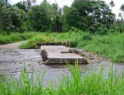
Although the Bougainville Coastal Trunk Road is the most important road in the Island, majority of the road facilities including bridges and causeway have been severely deteriorated due to the lack of maintenance activities during and after the hard years of the internal conflict. Many of the causeways on the road were collapsed or washed away by heavy flood water and causeways at 15 locations where the traffic were interrupted by flood water are selected to be reconstructed. All weather transportation on the road will be secured and the development and stability of the local people’s life in the Island will be promoted by the Project.
This is a grant aided project by the Japanese Government which is implemented by Japan International Cooperation Agency (JICA) and three counterpart agencies of Papua New Guinea: Department of National Planning and Monitoring (DNPM), Department of Works (DOW) and Autonomous Bougainville Government (ABG).
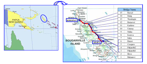
Collapsed Culvert at Rawa1
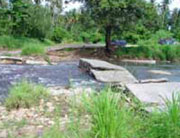
Collapsed Culvert at Warakapis
Ambulance Crossing on Riverbed
3. Project Outline
Substantial bridge structures are planned at each project site to avoid any disruption of traffic by flood water. The scale of the project and the length of 15 bridges are as shown below. The 4.0m width of carriageway and 1.0m of sidewalk is planned on the bridge deck.
| Bridge Name | Length (Span) | Bridge Name | Length (Span) |
|---|---|---|---|
| 1.Bakanovi | 75m (3@25m) | 9.Malas | 20m |
| 2.Bove | 20m | 10.Ururua | 20m |
| 3.Pukarobi1 | 25m | 11.Kaskrus | 25m |
| 4.Pukarobi2 | 50m (2@25m) | 12.Rotaovei | 20m (2@20m) |
| 5.Creepers | 20m | 13.Warakapis | 25m |
| 6.Ratavi | 50m (2@25m) | 14.Irung | 40m (2@20m) |
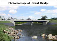
| 7.Iraka | 75m (3@25m) | 15.Rawa1 | 40m (2@20m) |
| 8.Korova | 20m | - | - |
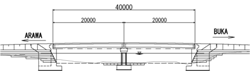
Side View of Rawa1 Bridge

Stakeholder Meeting at Ururua
4. Environmental and Social Considerations
The environmental and social issues caused by the project will be carefully examined. The ABG had stakeholder meetings at the each project site to acquire the consensus for the implementation of the project from the local residents. Through the stakeholder meetings, it is confirmed that the local peoples agreed to support the project amicably including the following subjects. (1) Use of land necessary for the project. (2) Cooperation for the smooth implementation of the project. (3) Solve any problem among local residents concerning the project through Community Coordination Committee including representatives of ABG, DOW and local people.
The project is categorized as Level2 of the environmental consideration, the environmental mitigation measure shall be implemented and monitorings based on the Environmental Management & Monitoring Plan are required during the construction.
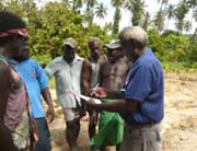
Stakeholder Meeting at Rawa1
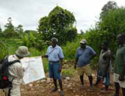
Stakeholder Meeting at Ururua
We sincerely hope that the project will contribute the development and stability of the Island and Papua New Guinea