Project News
2009-09-30
Changing Water Levels of Alhajuela Lake
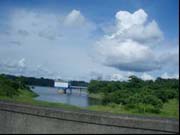
Alhajuela Lake that is in the Project's object area is an artificial lake that was formed by the construction of Madden dam on Chagres River. Everyday on our way to and from the Project office, we cross the bridge that passes over the dam. I was interested in knowing how the lake's water level changes during the year and I wanted to see the dam discharging water when the lake became completely full. In today's report, I would like to show the changes that occur in the water level of Alhajuela Lake.
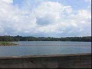
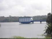
Photo 1 is a panoramic view of the lake from on top of the dam. Besides providing the Panama Canal with the water needed for the transiting of ships, Alhajuela Lake also is a source of drinking water for the population in Panama City's metropolitan area. Photo 2 shows the water level in July 2008. The rectangular structure in the center of the photo is the water intake for the water processing plant. The change in the lake's water level can be easily noted on the column that supports the water intake structure.
(Photo 1: left) View of Alhajuela Lake from Madden dam (November 12, 2008)
(Photo 2: right) Water intake structure. (July 18, 2008)
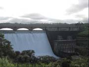
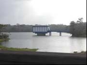
In Panama, the rainy season lasts approximately from April to November. The lake's level changes according to the amount of precipitation during the rainy season. In 2008, there was not much rain in the first part of the rainy season and therefore the level of the lake kept falling until October. Later, it rained a lot and the lake became full by December (photo 3). Then they began to discharge the dam's water. The concrete bridge that you see on top of the dam is the one we cross daily on our way to work (photo 4).
(Photo 3: left) The lake is nearly full. (December 10, 2008)
(Photo 4: right) View of water being discharged from the dam. (December 2, 2008)
Once we enter the dry season, the lake's level begins to descend. Photo 6 shows how the Alhajuela Lake shore looks when the water is low. You can see the bare shoreline. Where the lakeshore is more level, the local inhabitants plant corn and then harvest it before the lake begins to rise again. During the dry season, you have to walk on land where you can ride by boat when the lake is full.
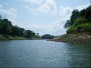
(Photo 5: left) The water level begins to fall in the dry season. (March 10, 2009)
(Photo 6: right) The lakeshore is exposed as the lake retreats. (April 21, 2008)
(Ms. Saito Yuka, Coordinator)