- Home
- Technical Cooperation Projects
- Index of Countries
- Oceania
- Vanuatu
- Project for Enhanching the Capacity of Issuing Earthquake, Tsunami and Storm Surge Information
- Project News
- Preparation for earthquake bulletin to share VMGD daily analysis activities
Project News
2019-09-30
Preparation for earthquake bulletin to share VMGD daily analysis activities
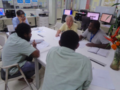
Van-REDI project targets the enhancement of observation, data analysis and information dissemination ability for earthquake, tsunami and storm surge. The project started in April and the expert for tsunami analysis has been staying for months in VMGD, sharing experiences through daily OJT (On the Job Training) activities to confirm VMGD's operations, improve them and share information among stakeholders.
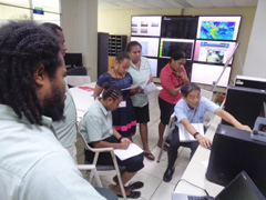
Vanuatu locates one of the most active seismic areas and we experience noticeable earthquakes frequently (a few in a month at capital city of Port Vila) same as or more than Japan. VMGD operates the seismic monitoring network in southern Pacific area, named The Oceania Regional Seismic NETwork (ORSNET), and daily analyzes seismic activities every day. The data includes location, depth of epicenter, magnitude and related parameters.
Van REDI project working group has been improving analytical method and developing scripts by using Graphical Mapping Tool (GMT*) developed by Hawaii university and completed preparation for regular issuance of Vanuatu earthquake activity map. The map shows earthquake activity with scaled/colored based on magnitude of earthquake and depth of epicenter so it is easy to understand the change of activity level and active area. VMGD plans to issue earthquake activity bulletin monthly with activity map and outlook analysis of earthquake activity to share it with media and publish on the VMGD web site to the public. (Figure 1)
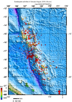 Figure 1 shows, how many earthquakes occur, which area earthquake activity is active in the month, bigger than M2, in Vanuatu area.
Additionally, the working group developed CMT analysis map**, (the map called beach-ball map), for earthquakes larger than magnitude 6 in southern pacific area for last 30 years, after collecting analysis data from research institutes. VMGD plans to prepare awareness materials using the beach-ball map to introduce seismic activities in and near Vanuatu area for the people to understand earthquake activities visually. (Figure 2)
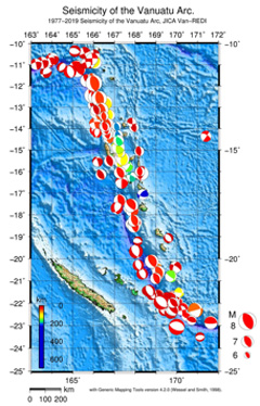 Figure 2 shows the focal mechanism as a "beach ball" map nearby Vanuatu (30 years, bigger than M6). This figure is also indicating predominant vertical displacement; namely a tsunamigenic earthquake or not, how faults move during earthquake events, colored area uplifted/shifted nearer and white area descended/shifted farer to/against epicenter.
VMGD has been storing useful analytic data through daily activities. The project continues supporting the regular publication of bulletins and sharing data to enhance the interests to earthquake/tsunami information and scientific analytic data.
* Graphic Mapping Tool:A geographical mapping tool developed by Hawaii university, mainly used in geo-hazard and meteorological research.
**Global Centroid Moment Tensor: A common method of earthquake mechanism analysis (mechanism of faults alignment) using the observed seismic waves.
Project team leader
Michihiko Tonouchi (Mr.)
- About JICA
- News & Features
- Countries & Regions
- Our Work
- Thematic Issues
- Types of Assistance
- Partnerships with Other Development Partners
- Climate Change / Environmental and Social Considerations
- Evaluations
- Compliance and Anti-corruption
- Science and Technology Cooperation on Global Issues
- Research
- JICA Development Studies Program / JICA Chair
- Support for the Acceptance of Foreign HRs / Multicultural and Inclusive Community
- Publications
- Investor Relations