Project News
2022-09-30
Monthly Report for September 2022
Conducted Public Awareness program in Pilot site, Essuna
On September 28, the Department of Culture (DOC), Ministry of Home and Culture Affaires, the Department of Disaster Management (DDM), and the Department of Engineering Services (DES), Ministry of Works and Human Settlement organized a public awareness program at Essuna village under Paro Dzongkhag, the project pilot site. In cooperation with the Paro Dzongkhag Administrative and the Essuna village head, more than 50 residents of Essuna village participated in the program.
In the morning session, the DDM presented the types of disasters that occur in Bhutan and the damage caused by the disasters. Simple measures to prevent furniture from overturning and things falling down in the event of an earthquake were also introduced. The DOC and DES introduced the seismic resilient house construction of rammed earth. The 3D animation and video created in the project were used to explain how to adopt the reinforcement measures in each construction phase.
In the afternoon, the DDM organized the field work in the village where the participants identified disaster risks and counter measures for disaster preparedness. Based on the outputs, the DDM is developing a disaster preparedness map that will be provided to the village.
"I would like to adopt the reinforcing measures which we learned today, when I build my house" said the village head. If such a practical example is coming up, the people in the village and surrounding area may also opt to build the seismic resilient houses.
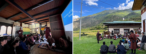 Video Program (left) Guidance before the village tour (right)
Photo courtesy of DOC
Conduct hands-on training (earthquake-resistant rammed-earth construction) by Department of Culture and Department of Engineering services
On September 26th and 27th (two days), the Department of Culture (DOC) of the Ministry of Home and Cultural Affairs and the Department of Engineering Services (DES) of the Ministry of Works and Human Settlement organized a Hand-on training on seismic resilient construction and retrofitting of stone masonry house for craftspeople (head carpenters and mason) and engineers of the district administrations at the experiment yard of the DOC. Nine head carpenters and masons from Essuna village under Paro District, the project pilot site and one engineer from the four Districts (Haa, Wangdue, Punakha and Thimphu) participated in the training. On the first day morning, the participants learnt the reinforcement measures and construction procedure watching the video on phase-wise construction. After that, the participants actually built up the foundation and wall with reinforced concrete post and band with the guidance of DOC and DES. Quality management is crucial, which requires better understanding of the adaptation and procedure. . The process of constructing a concrete post inside the wall of stone masonry and rammed earth, which is one of the most important process to reinforce the house was very new to the most of the participants. We received positive comments from the participants saying that they were given a good opportunity to understand that the rammed earth house also can be built seismically resilient with the minimal interventions. District officials will make their colleagues of what they learnt in the training.
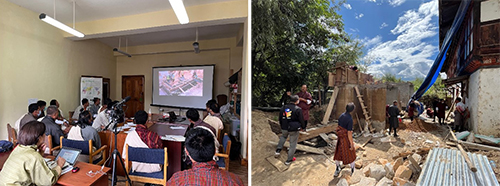 Learning of seismic construction procedure by video (left)
Seismic practice using a mock-up wall (right)
Learning of seismic construction procedure by video (left)
Seismic practice using a mock-up wall (right)
Photo provided by DOC
Mapping of Active fault in entire Bhutan at the Department of Geology and Mines
For about three weeks from September 19, with the guidance of Japanese researchers, an active fault mapping was carried out at the Department of Geology and Mines (DGM), Ministry of Economy. Active fault maps were made by identifying active faults based on "topographic displacement" using aerial photographs, which were then placed on the Digital Elevation Model on Google Earth. The counterparts learned how to identify active faults such as, "We identify a fault scarp here because there is a series of hill-facing scarp that cannot be formed by river erosion". During this work, they completed the map of active faults throughout Bhutan, and found many active faults, especially in the southern part of Bhutan. The results of this work will be compiled and published in a research paper.
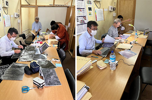 Sorting aerial photographs (left), Identifying active faults (right)
Photo courtesy: DGMs
- About JICA
- News & Features
- Countries & Regions
- Our Work
- Thematic Issues
- Types of Assistance
- Partnerships with Other Development Partners
- Climate Change / Environmental and Social Considerations
- Evaluations
- Compliance and Anti-corruption
- Science and Technology Cooperation on Global Issues
- Research
- JICA Development Studies Program / JICA Chair
- Support for the Acceptance of Foreign HRs / Multicultural and Inclusive Community
- Publications
- Investor Relations