- Home
- Technical Cooperation Projects
- Index of Countries
- Asia
- Timor-Leste
- Project for Community-based Sustainable Natural Resource Management
- Project News
- Participatory Land Use Planning (PLUP) activities have started.
Project News
2011-09-01
Participatory Land Use Planning (PLUP) activities have started.
The JICA and MAF Project Teams have started the participatory land use planning (PLUP) activities in the four project target villages, Suco Faturasa, Suco Fadabloco, Suco Talitu and Suco Madabeno, in June 2011 in partnership with NGOs based in Timor-Leste. In June 2011, local communities in the target villages discussed the present and future land use in the village and developed a future land use plan of the village with the assistance of the NGOs and JICA and MAF Project Teams.
In this project news, we would like to brief the outlines and major steps of PLUP.
(1) What is PLUP?
Participatory Land Use Planning (PLUP) is an interactive process in which local communities could discuss and determine how to manage the land and other natural resources in their locality. The same process has been introduced in a number of community-based forest and/or natural resource management projects in other countries and contributed to the introduction of sustainable forest and natural resource management on a village level.
What is unique in PLUP in the Project are to: i) encourage local communities to develop village regulations/by-laws including rules on natural resource management in writing in addition to a future land use plan; ii) assist local communities in holding a traditional ceremony to institutionalize the village regulations in a traditional manner; and iii) assist village leaders in monitoring the enforcement and implementation of the village regulations and future land use plan, to enable local communities to be a real manager of natural resources in their locality.
(2) Objective of PLUP
The main aim of PLUP is to orient local communities in the target villages toward the sustainable management of natural resources through development of a future land use plan and formulation of village regulations. Furthermore, PLUP would be effective in identification of supports/interventions necessary for materializing a future land use plan.
(3) Major Steps of PLUP
PLUP constitutes the following 10-step activities in the target villages.
- Step 1: Formation of a working group and preparation of a work plan
- Step 2: Exposure visit to Suco Faturasa
- Step 3: Present land use mapping
- Step 4: Future land use planning
- Step 5: Review of traditional rules in the past
- Step 6: Preparation of draft village regulations
- Step 7: Consultation with local communities about a future land use plan and draft village regulations
- Step 8: Coordination with the relevant government offices for approval/endorsement
- Step 9: Traditional ceremony to announce the village regulations and future land use plan to local communities in and around the village
- Step 10: Monthly monitoring of the enforcement and implementation of the village regulations and future land use plan
(4) Results of the Activities done in June 2011
Group Formation and Exposure Visit
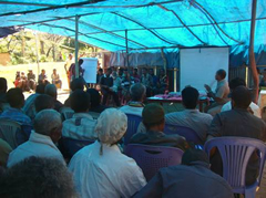
In the first week of June, the target villages except Suco Faturasa formed the working groups composed about 20 persons including the suco council members. On June 9, 2011, the members of the working groups of Suco Fadabloco, Suco Talitu and Suco Madabeno visited Suco Faturasa and were able to get a clear picture of the process and outputs of PLUP through discussions with the members of the working group in Suco Faturasa.
Present Land Use Mapping
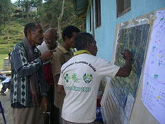
In the third week of June 2011, the working groups of the target villages except Suco Faturasa prepared the present land use maps of the respective villages using aerial photos with a scale of 1/7,500 or 1/10,000. In the session, the members of the working groups put major land marks, such as school and church, and depicted the boundaries of major land use categories, such as dense forest, sparse forest, coffee plantation, and shifting cultivation farm, onto the aerial photos covering the target villages.
Future Land Use Planning
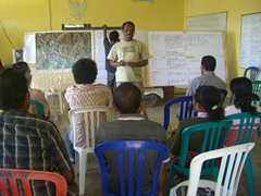
After present land use mapping, the working groups of the same villages further discussed the current management practices and future use of lands in the villages based on the present land use maps. In this step, the working groups discussed the following topics:
- Functions, values and importance of each type of land use;
- Extent and causes of forest and soil degradation in forests and other land uses;
- Potential rules on the use of forests and other land uses; and
- Future land use in the village.
All three working groups decided to: i) protect the existing dense natural forests; ii) improve the degraded natural forests with a medium density by planting new seedlings; iii) use the severely degraded forests with a sparse density for production purposes, such as production forests, coffee plantations and/or orchards; and iv) convert the existing shifting cultivation farms into coffee plantations, orchards, and permanent farms with soil conservation measures/agroforest techniques.
Review of Traditional Rules
The working groups of Suco Faturasa and Suco Madabeno reviewed the existing village regulations, while those of Suco Fadabloco and Talitu reviwed the traditional rules that they have obeyed in the Portuguese era. The results of the discussions in this step would be used for making the draft village regulations of the respective target villages.
(5) Next Project News
The PLUP activities in July 2011 will be briefed in the next project news.
- About JICA
- News & Features
- Countries & Regions
- Our Work
- Thematic Issues
- Types of Assistance
- Partnerships with Other Development Partners
- Climate Change / Environmental and Social Considerations
- Evaluations
- Compliance and Anti-corruption
- Science and Technology Cooperation on Global Issues
- Research
- JICA Development Studies Program / JICA Chair
- Support for the Acceptance of Foreign HRs / Multicultural and Inclusive Community
- Publications
- Investor Relations