- Home
- Technical Cooperation Projects
- Index of Countries
- Middle East
- Egypt
- Project for Strengthening Water Management Transfer
- Project News
- Mr. Nagai, a Short Term Expert was Dispatched to Egypt to See Possibility to Adopt the GIS.
Project News
2013-07-30
Mr. Nagai, a Short Term Expert was Dispatched to Egypt to See Possibility to Adopt the GIS.
Project for Strengthening Water Management Transfer (SWMT Project) invited Mr. Nagai, a short term expert on construction of Geographic Information System (GIS) from 1st to 15th June, 2013 to see possibility to adopt the GIS in the project. Based on his visit at the pilot sites and interviews with the relevant local stakeholders, Mr. Nagai recommended and gave his technical guidance of GIS framework to the SWMT Project
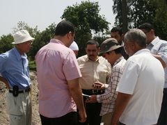 Visit at the pilot sites (Identifying the location by GPS)
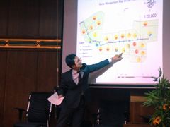 Mr. Nagai explaining about his activities to the Counterparts (CPs)
According to Geospatial Information Authority of Japan, GIS is defined as "a technology which makes it possible for us to do advanced analysis and swift judgement by generally managing, processing and visually indicating data (spatial data) which have information on locations based on geographic locations.
In water management transfer that the SWMT Project has been working for, various kinds of information on facilities (e.g. gates and pumps), canals (e.g. height, width, conditions, etc.), water (e.g. levels, quality and quantity), farmlands and villages around the canals will be collected, analyzed and understood, so that all the stakeholders can plan and implement solutions altogether.
As stakeholders, there are irrigation, environment and agricultural engineers, farmers and community people, etc. who have various different experiences and knowledge. Therefore, if the SWMT Project would like them to understand various information and analytical results, it is important to show them necessary information as clearly as possible. In this sense, the GIS can play its important role in facilitating their understandings of various information and analytical results by its visual aids on the maps.
Moreover, in process of developing the GIS, the stakeholders will discuss on necessary information for proper water management, and decide their roles and responsibilities to measure and collect the necessary information to establish a sustainable system. It is hoped that through establishment of that system, they can enhance their knowledge of water management and build a foundation to analyze and solve their local issues based on their continuous collection and sharing of the necessary information.
Mr. Nagai presented to many stakeholders the framework to adopt the GIS in the SWMT Project which he had developed through his activities in Egypt at a workshop in Tanta on 12th June as well as at the fourth Project Management Committee on 13rd June. We believe that they could better understand the GIS and take more interests in water management through a lively exchange of opinions.
From now on, the SWMT Project will soon start to implement the baseline survey in the pilot sites, and we hope to establish a system of water management transfer in which all the stakeholders can positively participate by effectively using the GIS.
- About JICA
- News & Features
- Countries & Regions
- Our Work
- Thematic Issues
- Types of Assistance
- Partnerships with Other Development Partners
- Climate Change / Environmental and Social Considerations
- Evaluations
- Compliance and Anti-corruption
- Science and Technology Cooperation on Global Issues
- Research
- JICA Development Studies Program / JICA Chair
- Support for the Acceptance of Foreign HRs / Multicultural and Inclusive Community
- Publications
- Investor Relations