Project News
2010-12-07
Field survey around Mt. Merapi
Mr. Toshiyasu UENO, Expert, Mr. Hariyono Utomo, Head of Sabo Technical Center and Dr. Takao YAMAKOSHI, Senior Researcher of Public Works Research Institute have implemented the field survey around Mount Merapi for 3 days from 5th to 7th December. The survey has been made with the following schedule: on 5th December - Boyong River as well as its downstream, Code River; on 6th December – Gendol River; on 7th December – Krasak River, Putih River, Apu River and Pabelan River.
In Boyong River (South side of Mt. Merapi); in the vicinity of the sabo dam about 9 km from the crater, riverbed was lifted up for more than 7m compared with that before the eruption and the sabo dam was filled with sediment. In Code River, which flows through Jogjakarta that is about 30km apart from the crater, riverbed was lifted up by the inflow of sediment from its upstream; where flood occurs frequently.
In Gendol River (South side of Mt. Merapi); pyroclastic flow has flown again and again at this eruption, which has caused many casualties. In the vicinity of about 6 km apart from the crater, houses and trees have been burnt by pyroclastic flow. In the vicinity of about 9 km apart from the crater, riverbed was lifted up about 20m compared with that before the eruption; in the vicinity of about 12 km apart from the crater, pyroclastic deposits were heaped up higher than the left and the right banks of the river. The sabo dam located about 15 km apart from the crater has caught pyroclastic flow. Surface of pyroclastic deposits reaches around 100oC, where steam is generated.
In Putih River (South-West side of Mt. Merapi); the sabo dam, which is apart 8 km from the crater, is filled with sediment; where debris excavate works was implemented in preparation for flood that may occur in the near future. In the vicinity of about 17 km apart from the crater, the river crosses with national highway; where due to shortage of cross sectional face of the channel, flood occurred at both the left and the right banks in the vicinity of a bridge over the national highway.
In Apu River (West side of Mt. Merapi); in the vicinity of the sabo dam apart from about 5 km from the crater, riverbed was lifted up by about 3m compared with that before the eruption, and the sabo dam was filled with sediment. In Pabelan River, the downstream of Apu River; the sabo dam apart from about 9 km from the crater has caught drift woods; furthermore, from the trace around it, it was estimated that the said sabo dam has cut the peak of debris flow.
In the meantime, volcanic action level of Mt. Merapi has been gotten down on 3rd December from the highest level 4 (preparation for evacuation) to the level 3 (warning); at the same time, evacuation order area has been narrowed to the sphere within 2.5 km in radius.
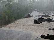 Sabo dam apart about 9km from the crater (Boyong River)
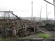 State of damages by pyroclastic flow at about 6km apart from the crater (around Gendol River)
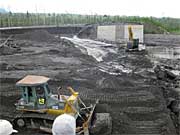 Sabo dam at about 8km apart from the crater (Putih River)
- About JICA
- News & Features
- Countries & Regions
- Our Work
- Thematic Issues
- Types of Assistance
- Partnerships with Other Development Partners
- Climate Change / Environmental and Social Considerations
- Evaluations
- Compliance and Anti-corruption
- Science and Technology Cooperation on Global Issues
- Research
- JICA Development Studies Program / JICA Chair
- Support for the Acceptance of Foreign HRs / Multicultural and Inclusive Community
- Publications
- Investor Relations