- Home
- Technical Cooperation Projects
- Index of Countries
- Asia
- Indonesia
- Integrated Disaster Mitigation Management Project for "Banjir Bandang"
- Project News
- Training at Tsukuba City, Ibaraki Prefecture
Project News
2011-02-01
Training at Tsukuba City, Ibaraki Prefecture
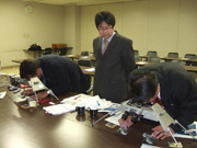 The exercises of interpretation of micro topography
On February 1st, Mr. Hariyono Utomo, the chief of Sabo Technical Center, Directorate General of Water Resources, Ministry of Public Works, and Mr. Edy, the head of Bakesbang(Residents protection agency) in Jember District, who have joined the counterpart trainings, attended training at Tsukuba City, Ibaraki Prefecture.
During the morning they visited JAXA Tsukuba Space Center Administration Department. Mr.Shin-ichiro Hayashi, Researcher in Erosion and Sediment Control Division, National Institute for Land and Infrastructure Management, explained observation of sediment disasters using "Daichi", Advanced Land Observing Satellite. He also explained that JAXA and National Institute for Land and Infrastructure Management collaborate in technology of grasping the picture and pictures about eruptions at Kirishima / Shinmoedake are provided to Erosion and Sediment Control Division by JAXA. The trainees asked questions such as frequency of satellite photo taking and possibility of using it in Indonesia.
At exercises of interpretation of micro topography in the afternoon, regarding deep-seated landslide which is a reason of Banjir Bandang disaster, Dr.Taro Uchida, Senior Researcher in Volcano and Debris Flow Research Team, Public Works Research Institute, explained methods of making "Map of Japan concerning deep-seated landslide" which were publicly-available and made focused on topographic quantity and geological age. Also, Mr.Osamu Yokoyama, Collaborating researcher, explained a method of extracting risk area of deep-seated landslide by interpreting micro topography from aerial photos. The trainees exercised interpretation of micro topography using stereoscopy.
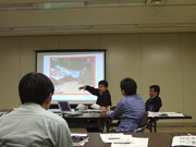 The Seminar
After that, a seminar was held for exchange information and opinions by Erosion and Sediment Control Division, National Institute for Land and Infrastructure Management and Volcano and Debris Flow Research Team, Public Works Research Institute. The seminar was about the current situation of sediment disaster and its control in both Japan and Indonesia. Japan made presentations regarding early evacuation from the view point of residents protection, which Mr.Edy is taking responsibilities , such as Critical Rainfall for Warning and Evacuation(Mr.Masaki Mizuno, Senior Researcher in National Institute for Land and Infrastructure Management), Method of designating sediment disaster risk area (Mr.Shin-ichiro Hayashi, Researcher in National Institute for Land and Infrastructure Management), Introduction of vibration sensor against volcanic disaster (Mr.Nagasumi Takezawa, Researcher in Public Works Research Institute). Indonesia made presentations by Mr.Edy about Banjir Bandang disaster in Jember District, Action plans at the time of disaster made with JICA experts, and Activities for establishing early evacuation and emergency measure which had been worked in JICA's projects. Also Mr.Utomo did about Banjir Bandang disaster occurrence in Indonesia, damage situation at the time of massive disaster, and its occurrence system. Very active questions and answers and discussions were made. Trainee asked questions about influences toward sediment disasters by climate change, etc.
- About JICA
- News & Features
- Countries & Regions
- Our Work
- Thematic Issues
- Types of Assistance
- Partnerships with Other Development Partners
- Climate Change / Environmental and Social Considerations
- Evaluations
- Compliance and Anti-corruption
- Science and Technology Cooperation on Global Issues
- Research
- JICA Development Studies Program / JICA Chair
- Support for the Acceptance of Foreign HRs / Multicultural and Inclusive Community
- Publications
- Investor Relations