- Home
- Technical Cooperation Projects
- Index of Countries
- Asia
- Indonesia
- Integrated Disaster Mitigation Management Project for "Banjir Bandang"
- Project News
- Held the training for making of the Banjir Bandang hazard map by GIS.
Project News
2011-12-02
Held the training for making of the Banjir Bandang hazard map by GIS.
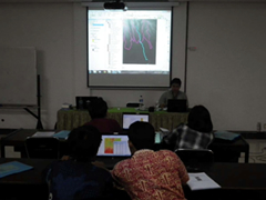
JICA have already made the hazard map in Jember by GIS which referred to Japanese method. This map can show the ability for deep-seated landslide areas, which were one cause of the Banjir Bandang, and the Banjir bandang flooded areas by the GIS analysis of satellite photograph and digitalized topological data.
JICA held the training for making of the Banjir Bandang hazard map to understand the method very well, though the Short-term experts had already lectured the method to staff of the Public Work Agency in East Java Province on September. So that the attendees weren't belong to only the Public Work Agency (Dinas PU), but also the Disaster Management Agency in East Java Province (BPBD) and the Brantas River Basin Office in Ministry of Public Works (BBWS Brantas) as counterparts.
The training was held in December 1st and 2nd. There was the lecture about model site activity by Mr. Yoshida Expert firstly, and the training was held by the staff of the local consultant.
Participants had a hard time firstly to operate the GIS software. They learned the operation of digital topological data, satellite data and so on for analysis and the ways for analysis to make the hazard map.
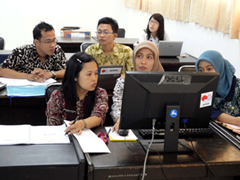 Participants heard the lecture.
 On the taraining.
- About JICA
- News & Features
- Countries & Regions
- Our Work
- Thematic Issues
- Types of Assistance
- Partnerships with Other Development Partners
- Climate Change / Environmental and Social Considerations
- Evaluations
- Compliance and Anti-corruption
- Science and Technology Cooperation on Global Issues
- Research
- JICA Development Studies Program / JICA Chair
- Support for the Acceptance of Foreign HRs / Multicultural and Inclusive Community
- Publications
- Investor Relations