- Home
- Technical Cooperation Projects
- Index of Countries
- Asia
- Indonesia
- Integrated Disaster Mitigation Management Project for "Banjir Bandang"
- Project News
- Held the training for making of Banjir Bandang Hazard Map by GIS in Palu.
Project News
2012-01-19
Held the training for making of Banjir Bandang Hazard Map by GIS in Palu.
JICA held the training to introduce their activity fruits in Jember and make Banjir Bandang Hazard Map by GIS at Palu in Central Sulawesi Province.
There were three days training from January 17th to 19th, 2012. Firstly Mr. Yoshida Expert made a presentation about JICA activity in Jember and discussed with participants about the installing location of rainfall gauge and the latest observation of landslide.
Next, two participants used one laptop to learned the analysis and making of Banjir Bandang Hazard Map by GIS as same as the training held in East Java Province. Participants from the Sulawesi 3rd River Office in Ministry of Public Works (BWS Sulawesi III), the Public Works Agency (Dinas PU) in Central Sulawesi Province, the Disaster Management Agency (BPBD) in Central Sulawesi Province, the Public Works Agency (Dinas PU) in Palu city and Ministry of Public Works (PU) seem to study hardly how to make the Banjir Bandang Hazard Map.
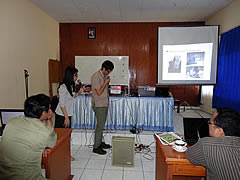 Mr. Yoshida Expert demonstrated the rainfall gauge operation.
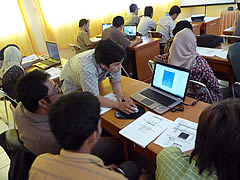 Participants learned the GIS software.
- About JICA
- News & Features
- Countries & Regions
- Our Work
- Thematic Issues
- Types of Assistance
- Partnerships with Other Development Partners
- Climate Change / Environmental and Social Considerations
- Evaluations
- Compliance and Anti-corruption
- Science and Technology Cooperation on Global Issues
- Research
- JICA Development Studies Program / JICA Chair
- Support for the Acceptance of Foreign HRs / Multicultural and Inclusive Community
- Publications
- Investor Relations