Project News
2009-09-28
Watershed surveys in Jember District
Watershed surveys in Jember District have been conducted in Banjir Bandang Disaster Mitigation Management Project at the moment.
In Jember district, there are series of Hyang Mountain groups in the north including Mt. Argopuro, at a height of 3088m, which are topographically precipitous. Furthermore, great part of watershed is covered by volcanic products, which is geologically fragile. In addition, it is peculiarly pluvial and is in the condition where sediment disasters tend to occur.
Concerning the vegetation, single vegetation by logged forests after deforestation (cleaning) or plantation is found largely in the mountain slope at each basin area in general. Illegal logging often happens, even though the controls over illegal logging have been tightened, which have the least effect.
While large and small areas after collapse, sediment deposition, small crack of slope, etc. are found in basins, some of the villages are formed just beneath such a slope or along a mountain stream, which are in peril of disasters, such as landslide, debris flow, etc.
We will pursue field investigations furthermore and figure out the basin conditions as well as supporting local governments to take appropriate countermeasures.
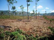
Photo: Upper river basin of Harjomulyo village. No trees to be called trees can be found from the hill zone in front to the mountain slope behind.
- About JICA
- News & Features
- Countries & Regions
- Our Work
- Thematic Issues
- Types of Assistance
- Partnerships with Other Development Partners
- Climate Change / Environmental and Social Considerations
- Evaluations
- Compliance and Anti-corruption
- Science and Technology Cooperation on Global Issues
- Research
- JICA Development Studies Program / JICA Chair
- Support for the Acceptance of Foreign HRs / Multicultural and Inclusive Community
- Publications
- Investor Relations