- Home
- Technical Cooperation Projects
- Index of Countries
- Asia
- Laos
- Sustainable Forest Management and REDD+ Support Project
- Project News
- Survey of years taken for forest regeneration in NFI 2016-2017
Project News
2017-02-16
Survey of years taken for forest regeneration in NFI 2016-2017
The National Forest Inventory (NFI) survey for the dry season 2016-2017 started at the end of October after the classroom and field trainings. As in the previous (2015-2016) dry season survey, forest resource information is collected with a focus on forest biomass. The NFI will enable estimation of the carbon stock in Lao forests; and hence, will also facilitate estimations of the amount of CO2 emitted to or removed from the atmosphere.
REDD+ requires the participating countries to clearly distinguish non-forest and forest according to the national forest definition. However, in Lao PDR where slash-and-burn agriculture is widely practiced, accurate interpretation of the transition (regeneration) from slash-and-burn land (non-forest) to forest on satellite imagery has been a big challenge.
To cope with this, a supplementary survey is ongoing in five provinces to clarify the number of years abandoned agricultural lands would need to regenerate to forests (threshold year) after being slashed and burnt. The survey for investigating the threshold year consists of two components: a combination of tree crown cover analysis from aerial photos taken by Unmanned Aerial Vehicles (UAV), or so called "drones", and field measurement of diameter at breast height (DBH); and assessment of abandoned year of the sites. As Lao PDR does not have clear information on the number of years for slash and burn land to regenerate to a forest, the survey is vital for Lao PDR to improve its forest carbon stock estimation.
This survey of forest to non-forest change is also working on measuring the biomass of the lands which do not yet meet the national definition of forests, but have potential to regenerate to forests in the future (so called "potential forests"), through sample collection of above-ground vegetation. This will improve the estimation of biomass and carbon stock of non-forest lands.
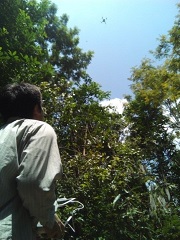 Survey using a UAV
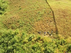 Aerial photo taken by a UAV; agricultural land after being abandoned one year (lower part), and newly cleared land for agriculture (upper part)
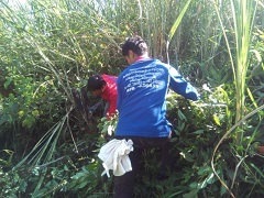 Sample collection of biomass
- About JICA
- News & Features
- Countries & Regions
- Our Work
- Thematic Issues
- Types of Assistance
- Partnerships with Other Development Partners
- Climate Change / Environmental and Social Considerations
- Evaluations
- Compliance and Anti-corruption
- Science and Technology Cooperation on Global Issues
- Research
- JICA Development Studies Program / JICA Chair
- Support for the Acceptance of Foreign HRs / Multicultural and Inclusive Community
- Publications
- Investor Relations