- Home
- Technical Cooperation Projects
- Index of Countries
- Asia
- Laos
- Sustainable Forest Management and REDD+ Support Project
- Project News
- Designing and development of the National Forest Monitoring System
Project News
2017-08-25
Designing and development of the National Forest Monitoring System
The developing countries implementing REDD+ are required to monitor and report the REDD+ activities precisely and transparently by stepwise development of the National Forest Monitoring System (NFMS). The consensus on the scope and roadmap of the NFMS in Laos has been developed through the REL/MRV Technical Working Group and other technical discussions. It was agreed that the NFMS would be developed, as the first step, to equip the function to measure (M of MRV*) emission and removal of carbon dioxide (CO2).
The NFMS prototype has already set up in the server of the Department of Forestry (DOF), and stores the satellite image data, the Forest Type Maps (2000, 2005 and 2010), Forest Cover Change Maps, the result of the National Forest Inventory (NFI) which is the national scale forest survey, and other related data. Also, using these data, NFMS can calculate the area/change area of the forest types at national or provincial level, and also to calculate CO2 emission/removal and their change.
The function development and data installation as the first plan will be completed through final check of the system in December 2017. At the same time, the training for management and operation of the NFMS will be conducted for three weeks in November with the purpose of the capacity development of DOF officials to maintain, operate and improve the NFMS sustainably.
In 2018 or after, F-REDD is aiming the full-scale operation of the NFMS by feedback; extract challenges, sort out measures and improve the systems and will also expand the functions such as the forest monitoring. F-REDD will continue to support for improvement of the NFMS in collaboration with other donors.
* MRV: is the system to carry out the measurement, reporting, and verification of the REDD+ results of emission reductions of greenhouse gases.
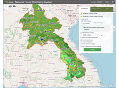 Forest Type Map shown on the NFMS
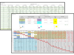 Area of each forest type and CO2 emission/removal change calculated by NFMS
- About JICA
- News & Features
- Countries & Regions
- Our Work
- Thematic Issues
- Types of Assistance
- Partnerships with Other Development Partners
- Climate Change / Environmental and Social Considerations
- Evaluations
- Compliance and Anti-corruption
- Science and Technology Cooperation on Global Issues
- Research
- JICA Development Studies Program / JICA Chair
- Support for the Acceptance of Foreign HRs / Multicultural and Inclusive Community
- Publications
- Investor Relations