- Home
- Technical Cooperation Projects
- Index of Countries
- Asia
- Laos
- Sustainable Forest Management and REDD+ Support Project
- Project News
- National Forest Monitoring System and Near real-time Provincial Deforestation Monitoring System now being developed
Project News
2018-07-10
National Forest Monitoring System and Near real-time Provincial Deforestation Monitoring System now being developed
Under the United Nations Framework Convention on Climate Change (UNFCCC), REDD+ participating countries are required to accurately measure and report greenhouse gas emissions reduction and removal based on REDD+ activities in a transparent manner by developing and utilizing a National Forest Monitoring System (NFMS). The NFMS for which F-REDD is providing support for development in Lao PDR already includes information such as satellite imagery, forest type maps, forest change maps, and national forest inventories. A function has already been installed to apply this data to calculate the area of interest by forest type, CO2 emissions and removal, as well as changes in each of these, both nationwide and by province. Currently, to ensure transparency, progress is being made on revisions to the NFMS in preparation for access by public. Additionally, efforts are underway to expand the system step by step to allow centralized management of data related to REDD+ through registration of all REDD+ projects and programs within Laos and the addition of an emissions reduction registry function.
In 2018, F-REDD started providing support for the development and trial implementation of Near real-time Provincial Deforestation Monitoring System. The most significant factor resulting in deforestation in Laos is the conversion of land use from forestry to agriculture, therefore monitoring the expansion of slash-and-burn agriculture and commercial crop cultivation into forest areas and taking appropriate measures as required is indispensable. However, such activities in these areas are still not fully functional, due to lack of clarity in forest demarcation and in definitions of monitoring structures and implementation methods. Plans call for the development and trial introduction of Near real-time Provincial Deforestation Monitoring System to use satellite imagery for early detection of deforestation, thereby enabling various appropriate measures, including checking the current situation through on-site patrols by forestry officials and responding appropriately. Plans also call for storing information on deforestation collected using this monitoring system in the NFMS database for use in various reports.
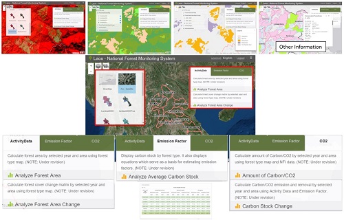 Overview of Lao PDR's National Forest Monitoring System (NFMS)
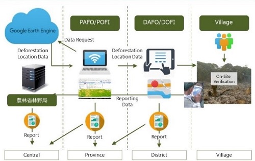 Conceptual diagram of the Near real-time Provincial Deforestation Monitoring System
- About JICA
- News & Features
- Countries & Regions
- Our Work
- Thematic Issues
- Types of Assistance
- Partnerships with Other Development Partners
- Climate Change / Environmental and Social Considerations
- Evaluations
- Compliance and Anti-corruption
- Science and Technology Cooperation on Global Issues
- Research
- JICA Development Studies Program / JICA Chair
- Support for the Acceptance of Foreign HRs / Multicultural and Inclusive Community
- Publications
- Investor Relations