- Home
- Technical Cooperation Projects
- Index of Countries
- Asia
- Laos
- Sustainable Forest Management and REDD+ Support Project
- Project News
- Testing the new deforestation monitoring system using satellite imagery
Project News
2019-01-25
Testing the new deforestation monitoring system using satellite imagery
In northern Laos, the conversion of forests into agricultural land is a major driver of deforestation and forest degradation. For the implementation of REDD+, there is an urgent need to establish a forest monitoring system to avoid the expansion of slash-and-burn agriculture, commercial crop cultivation, and concession areas into the forests that should be protected. In 2018, F-REDD started developing a near-real-time forest monitoring system using free satellite imagery. In January 2019, training sessions were provided for the provincial and district forestry officers of Luang Prabang Province — before testing the system in the provincial protection forests in the pilot sites during the dry season from January to April 2019.
The use of free satellite imagery makes it possible to provide far less expensive and more efficient, accurate information on deforestation. We are also developing an application which allows forestry officers in the field to input monitoring results into tablet devices for reporting. This will enable easier reporting of field survey data and control of the collected data through a unified management system. This monitoring system will also be tested during the 2020 dry season, and user feedback will be reflected in system improvement. In the future, it is hoped that the system will become a tool for participatory forest monitoring to reduce deforestation.
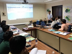 Forest monitoring classroom training
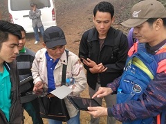 Forest monitoring field training
- About JICA
- News & Features
- Countries & Regions
- Our Work
- Thematic Issues
- Types of Assistance
- Partnerships with Other Development Partners
- Climate Change / Environmental and Social Considerations
- Evaluations
- Compliance and Anti-corruption
- Science and Technology Cooperation on Global Issues
- Research
- JICA Development Studies Program / JICA Chair
- Support for the Acceptance of Foreign HRs / Multicultural and Inclusive Community
- Publications
- Investor Relations