- Home
- Technical Cooperation Projects
- Index of Countries
- Asia
- Laos
- Sustainable Forest Management and REDD+ Support Project
- Project News
- Scaling up of Provincial Deforestation Monitoring System
Project News
2020-06-18
Scaling up of Provincial Deforestation Monitoring System
F-REDD has developed a satellite-based Provincial Deforestation Monitoring System (PDMS) as a tool that utilizes satellite images for deforestation monitoring, and has strengthened the implementation system for forest monitoring at the provincial and district levels. F-REDD conducted deforestation monitoring of village forest areas during the dry season (January to April) in 2020 in cooperation with the forestry sections of the provinces of Luang Prabang and Oudomxay. As a result, 55 cases of deforestation were reported on 19,600 hectares of village forest area in 16 villages of Luang Prabang, and 82 cases on 19,000 hectares of village forest area in 5 villages of Oudomxay. According to a review by forestry officers who actually used the PDMS in the forest monitoring, the PDMS is a tool that is simple and practical enough to be used even without expertise in satellite image analysis or GIS, and it enabled more effective and efficient monitoring.
The PDMS developed and tried this time is planned to be expanded to other areas in the future. F-REDD will continue to support the expansion of PDMS implementation in three northern provinces, including Luang Prabang, in collaboration with the REDD+ implementation project funded by the GCF. In addition, Oudomxay has expressed its intention to expand the PDMS to other districts by using funds from the Forest Carbon Partnership Facility (FCPF) project.
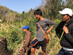 Inspection of deforestation area with villagers
- About JICA
- News & Features
- Countries & Regions
- Our Work
- Thematic Issues
- Types of Assistance
- Partnerships with Other Development Partners
- Climate Change / Environmental and Social Considerations
- Evaluations
- Compliance and Anti-corruption
- Science and Technology Cooperation on Global Issues
- Research
- JICA Development Studies Program / JICA Chair
- Support for the Acceptance of Foreign HRs / Multicultural and Inclusive Community
- Publications
- Investor Relations