- Home
- Technical Cooperation Projects
- Index of Countries
- Africa
- Mozambique
- Project on Strengthening Resilience in Cyclone IDAI-Affected Areas
- Project News
- The 1st Technical Training was conducted in Maputo and Beira City
Project News
2020-01-21
The 1st Technical Training was conducted in Maputo and Beira City
"Formulation of recovery action plan and evacuation plans based on hazard maps" is one of the important outputs in this project. The counterpart organizations such as CENOE (Centre for Emergency Operation) and PCIRC (Post Cyclone Idai Reconstruction Cabinet) requested JICA to demonstrate the creation of a hazard map, the technique to interpret the hazard map and the development of human resources to formulate an evacuation plan. Since these counterpart organizations do not have enough capacity and experience on requested points, the technical training was held immediately after the request in order to develop topographic maps required to create hazard maps and to deeply understand the targeted types of hazard for the Beira City Officers in charge of this target project.
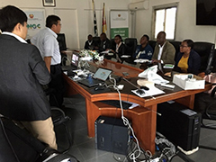 Technical training in Maputo City (At the lecture of GIS/topographic mapping)
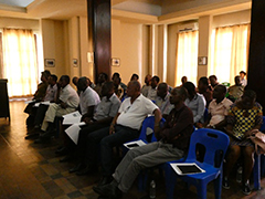 Technical training in Beira City (At the lecture of storm surge/hazard analysis overview)
Creating topographic maps and understanding targeted types of hazard through lectures:
Trainees had lectures on making a topographic map required for creating a hazard map, the outline of hazards (storm surge and drainage), land use plan, and evacuation plan. The trainees were CENOE officials in Maputo City and Beira City officers in Beira City.
The trainees of Maputo City had few questions and answers to the lectures as it was almost the first time for trainees to have training on GIS / topographic map creation, storm surge disaster and hazard map creation. However, they were very interested in the land use/evacuation planning overview, and in particular, they seemed to be considering whether GIS could be utilized for formulation of recovery action plan, land use plan and evacuation plan.
On the other hand, the trainees of Beira City actively engaged in discussions on GIS/topographic maps, hazards (storm surge/drainage), and land use/evacuation planning overview to deepen their understandings of the lectures.
JICA Team will continue to provide these training opportunities in response to local needs.
Fieldwork training for Beira City officers:
In addition to the lectures, trainees in Beira City learned the methods of on-site surveys and the importance of storing collected data through the field survey training of storm surge trace.
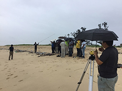 Fieldwork training in Beira City (At the field survey of storm surge traces)
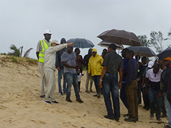 Field survey training in Beira City (During the instruction on the survey of storm surge trace)
- About JICA
- News & Features
- Countries & Regions
- Our Work
- Thematic Issues
- Types of Assistance
- Partnerships with Other Development Partners
- Climate Change / Environmental and Social Considerations
- Evaluations
- Compliance and Anti-corruption
- Science and Technology Cooperation on Global Issues
- Research
- JICA Development Studies Program / JICA Chair
- Support for the Acceptance of Foreign HRs / Multicultural and Inclusive Community
- Publications
- Investor Relations