- Home
- Technical Cooperation Projects
- Index of Countries
- Asia
- Myanmar
- Integrated Mangrove Rehabilitation and Management Project through Community Participation in the Ayewady Delta
- Project News
- Updating Land Use Map and Hazard map in the Project Area Area
Project News
From September 2012 to February 2013
Updating Land Use Map and Hazard map in the Project Area
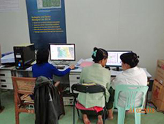 GIS Analysis at FD GIS Section
As a part of activities of project Output4 and OutputX, a land use map and a hazard map were updated by FD GIS section and JICA Expert Team (JET) using the latest satellite image (2012). The project initiated this updating work from September 2012, and completed the work by February 2013. Compared with land use maps in 2007 and 2009, 2012 satellite image revealed that mangrove forest within the project area seemed to be degreased and remained only 25% of the project area. On the other hands, settlement areas, shrimp ponds and agriculture lands including grass land were increased.
To promote awareness of disaster prevention in the delta, JET and FD GIS section updated a hazard map which was prepared in 2009(after the cyclone Nargis). This time, emphasis was more given to "user-friendly" hazard map. The project evaluated hazard level into four classes using parameters such as land use situation, river network situation and location of cyclone shelters and CFECNs in the project area. Updated land use map and hazard map were presented in the final mangrove seminar and technical workshop and distributed to relevant stakeholders.
FD GIS section is highly expected to continue regular updates of map information for contributing to appropriate land use management as well as disaster prevention in the delta.
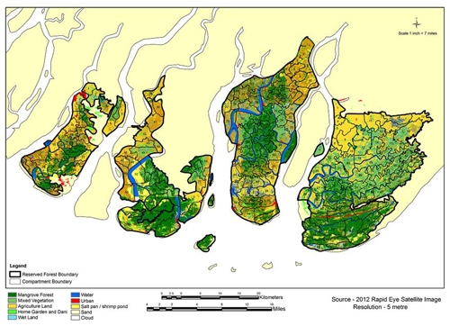 Land Use Map 2012
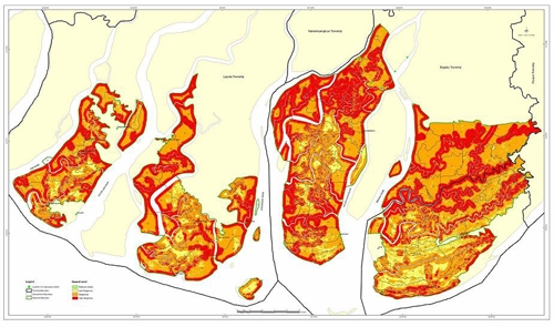 Hazard Map 2013
- About JICA
- News & Features
- Countries & Regions
- Our Work
- Thematic Issues
- Types of Assistance
- Partnerships with Other Development Partners
- Climate Change / Environmental and Social Considerations
- Evaluations
- Compliance and Anti-corruption
- Science and Technology Cooperation on Global Issues
- Research
- JICA Development Studies Program / JICA Chair
- Support for the Acceptance of Foreign HRs / Multicultural and Inclusive Community
- Publications
- Investor Relations