- Home
- Technical Cooperation Projects
- Index of Countries
- Oceania
- Tuvalu
- Project for Eco-technological management of Tuvalu against sea level rise
- Project News
- For Foram Sand arriving at the Fongafale Beach
Project News
2009-11-09
For Foram Sand arriving at the Fongafale Beach
To create sandy beaches, lots of foram need to drift and accumulate at Fongafale after they die.
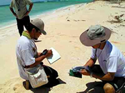
The coastal technology team and the remote sensing team study foram transport and sedimentation.
The team survey from the north end to the south end of the Fongafale islet to grasp the 3-D profiles of this islet.
The coast of the Fogafale is divided by the beach rocks, sandy beach and reef flat. They grasp these conditions by GPS(Global Positioning System). These surveys are undergone several times. Comparing these data, they measure the movement of the sands such as segmentation and erosion. They also measure the current speed and wave height periodically.
The remote sensing team collects the data from the satellite pictures and web camera data to find the movement of the coast by the seasonal event or time in a day over several years.
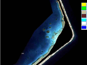
All the information from each team feed into the GIS(Geographic Information System) to make a habitat-sand sediment balance map.
Mobilizing all the results of the research, we will advise the countermeasure to recover the coastal latent ability against the erosion.
At the same time, we will ensure the other coastal protection plans do not to conflict with the natural land formation system. We also aim for these plans to support natural land formation.
Though this project, we build our local capacity for the eco-technological management so that Tuvaluan people can protect the country by their own hands.
Wording Responsible: Fumiko Matsudate (Project Coordinator)
- About JICA
- News & Features
- Countries & Regions
- Our Work
- Thematic Issues
- Types of Assistance
- Partnerships with Other Development Partners
- Climate Change / Environmental and Social Considerations
- Evaluations
- Compliance and Anti-corruption
- Science and Technology Cooperation on Global Issues
- Research
- JICA Development Studies Program / JICA Chair
- Support for the Acceptance of Foreign HRs / Multicultural and Inclusive Community
- Publications
- Investor Relations