


scroll

1. Scheme
Technical Cooperation
2. Counterpart Organization
Papua New Guinea Forest Authority (PNGFA)
3. Project Duration
2014/8 ~ 2019/8
4. Introduction
PNG has the largest tropical rainforest in the Pacific region. It is the third largest rainforest in the world. This project is aimed at assisting in effective management of this vast natural resource, by operationalizing the PNG Forest Resource Information Management System that has been developed under the preceding project ‘The Capacity Development on Forest Resource Monitoring for Addressing Climate Change in Papua New Guinea’ (2011-2014).
The tropical rainforest plays important roles, contributing to the national economy through timber exports, preservation of rich biodiversity and mitigation of climate change. However, PNG's forest area coverage has decreased, and deforestation and forest degradation have been posing serious problems.
In order to address these challenges, JICA and PNGFA collaborated in the 2011-2014 project, combined with the Japanese Grant Aid Program that provided the project with remote sensing data, GIS equipment, and training program for the officers of PNGFA and other relevant government agencies. The project successfully developed the Nation-wide Forest Base Map and the National Forest Resource Information Management System (NFRIMS) - a platform essential to addressing climate change issues, especially in the development of the Measuring, Reporting and Verification (MRV) system in PNG.
The new project, starting from August 2014 for 5 years, kick-starts from where the previous project left off. It aims to reinvigorate the capacity of PNGFA so that it can fully operationalise the NFRIMS, including capacities to update and manage forest coverage and stocks on GIS, efficient forest monitoring system, improvement of inter-agency coordination and technical capacity for REDD+ reporting, and development of appropriate training programs.
The major outcomes expected from the new project include carbon accounting, which is one of the indispensable elements to address climate change issues in PNG.
5. Target Provinces
The whole area of PNG
6. The Snapshots of the Project
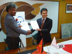
Mr. Shigeru Sugiyama (right), Chief Representative of JICA PNG Office, and Mr. Kanawi Pouru (left), Managing Director of PNGFA, agreed on the framework of this project. Finally, they concluded the Record of Discussion (R/D) on 27/Mar/14.
7. More Information
-
Project pamphlet for "Capacity Development Project for Operationalization of PNG Forest Resource Information Management System for Addressing Climate Change 2014-2019" (PDF/1.18MB)
-
Renewed project pamphlet for "Capacity Development Project for Operationalization of PNG Forest Resource Information Management System for Addressing Climate Change 2014-2019" (25th January 2016) (PDF/597KB)
-
Project pamphlet for “Capacity Development on Forest Resource Monitoring for Addressing Climate Change 2011-2014” (6th November 2014) (PDF/753KB)
8. Recent Activities
- Field visit to Project Pilot site in West Sepik Province
- Workshop of the PNGFA-JICA Technical Cooperation Project on 1st Aug,2017
- Field visit to Project Pilot site in West New Britain Province on 5th May, 2017
- Third Joint Coordinating Committee (JCC) of the JICA Technical Cooperation Project held on 25th August, 2016
- Workshop on improvement of monitoring system, 3rd June 2016
- Report on Papua New Guinea's participation in COP21
- Second Joint Coordinating Committee (JCC) on 19th August, 2015
- Training in Japan for PNG Forest Authority Project Counterpart staff in September 2015
- Project Team's participation in COP20 in December 2014
- First Joint Coordinating Committee (JCC) on 19th September 2014
9. Project Work
Papua New Guinea Forest Base-Map and Atlas (2019-07-31)
PNG-FRIMS -Main Report-
Fact Sheet
-
No.1 JICA-PNGFA PROJECT Outline (PDF/446KB)
-
No.2 Papua New Guinea Forest Base Map 2012 (PDF/493KB)
-
No.3 PNG-FRIMS (PDF/742KB)
-
No.4 Forest Monitoring Unit (FMU) in Papua New Guinea Forest Cover Map (FMU) (PDF/403KB)
-
No.5 Constraints data Natural condition layers in the PNG-FRIMS (PDF/247KB)
-
No.6 Watershed and Catchment Data (PDF/541KB)
-
No.7 Digitized Road Information (PDF/947KB)
-
No.8 Forest Concession and Land Management Layers in PNG-FRIMS (PDF/666KB)
-
No.9 Forest Cover Map 2015 (PDF/624KB)
-
No.10 Drone Applications in Sustainable Forest Management and Monitoring in PNGFA (PDF/1.21MB)